
Yesterday two of my housemates and I traveled up to County Claire to the town of Ennis and the Cliffs of Moher. The final destination of the trip, the Cliffs, was the furthest point north I had yet traveled to in Ireland and was the first time I had seen the Atlantic Ocean from Ireland. I had also never been to County Claire before, so the trip included a number of interesting new places.
It began with a bus that left Cork City at around 7.30 in the morning, which was not so much fun to wake up for. We then switched buses in Limerick and eventually stopped in Ennis. We had about four hours between our arrival in Ennis and the next bus to Doolin and the Cliffs of Moher so we had lunch and wandered around town for a few hours. Ennis is the largest town in County Claire and since Claire play Cork in an important hurling match tomorrow the town itself was draped in yellow and blue banners.
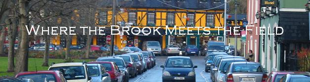
In Ennis we visited the creatively named Ennis Friary, which is right next to the Fergus River and was built in the 13th century. The town itself grew up around the friary, which was built by the ruling O'Brien family near their stronghold. Ennis itself is a nice town, considerably smaller than Cork with narrow streets and a rather small downtown area that includes a few main streets. The picture at the top of the post is of the main street of Ennis taken from the base of the O'Connell monument at the center of town. Below is the Friary.

After a few hours and lunch in Ennis we returned to the bus station to start the 50 minute bus ride to the Cliffs of Moher. The bus ride from Ennis to the cliffs provided gorgeous views of the Claire countryside. Claire is far rockier than Cork. Rolling hills extend into the distance covered with rocky-spotted fields bordered by rock walls, a sharp contrast to the empty grass fields bordered by hedges and trees of County Cork to which I am more accustomed. The main road to the cliffs passes a large quarry not far outside the town of Ennis. After about a half hour or so we came over the crest of a hill and saw a large bay (Lehinch, i believe), which was the first view of the Atlantic Ocean I have had since landing in Cork. The town of Lehinch (once again I am not positive that it is this specific town) had a couple of really cool-looking golf courses that had ruins of some ancient-looking fortifications between fairways. After we passed the golf courses we passed a very long, wide beach. We followed the curve in the bay and then started climbing the hill that would eventually take us to the top of the cliffs. Looking back from the bus:

We eventually got to the cliffs themselves and they were rather breathtaking. It was actually sunny or only partly cloudy for most of the day and fairly clear, so we got a good view of the cliffs and the surrounding countryside. The cliffs are about five miles long and rise slightly more than 700 feet above sea level at their highest point. They're pretty incredible.
 The picture above is looking in the wrong way for them, but since it was clear we could also see the Aran Islands in the distance. There was also a stone watchtower near the middle of the cliffs, O'Brien's Tower (in the picture below).
 Just as we were about to catch a bus back it started raining faintly and as the bus ride began it started pouring. Good timing on our part.

1 comment:
Beautiful pictures!
Post a Comment