Showing posts with label tourism. Show all posts

Monday, August 11, 2008

A Green, Wet Peninsula (Part 2)


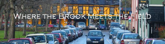
To pick up from where I left off last night, we checked into our hotel. The view from our hotel window is above. From there we drove back to the town of Dingle, which was a few miles from our hotel, and began our westward loop around the coast.

As we set out west from Dingle the rain, which had been on and off all day, began to let up and the misty fog that had shrouded the peninsula since we had arrived began to gradually lift. We proceeded around Dingle Harbor to the next protected bay, Ventry. There we stopped at a beach and circled around the bay to look at it from the other side. At this point it is a lot easier to just use pictures:

We then proceeded further west towards the eventual tip of the peninsula, stopping a few times along the way to appreciate the breathtaking scenery and wonderful ocean views, which got better and better as the visibility gradually improved. We stopped at Dunbeg Fort, a Stone Age archaeological site on the edge of a coastal cliff. We stopped at a few curves in the road, passed a hairpin turn where a rather substantial stream flowed over the roadway, and suffered through the nerve wracking experience of driving on the incredibly narrow roads that were pretty much directly on the edge of cliffs. At one bend in the road (at Slea Head) we saw a crucifix which seemed rather randomly placed, and no obvious reason for its location was given. We passed Ryan's Daughter, the westernmost point on the peninsula, and eventually proceeded back to our hotel for dinner.

As we went to bed, we could hear rain pounding outside and the wind howling across the hills of Dingle. We were pretty much in the middle of nowhere, and it was great.

The next morning we returned to Ryan's Daughter and hiked out through fields sprinkled with sheep to the westernmost point on the Dingle Peninsula. It was VERY windy on the summit of Ryan's Daughter, which is actually a slight hill in addition to a finger of land extending into the Atlantic Ocean. As we walked out to the small stone hut on the hill, it began to rain in a very light, misty, cold fashion, blown in from the ocean. This sort of rain persisted intermittently for the next few hours.

We then went about a mile north to hike out to the end of the next finger of the peninsula, which does not extend as far west and is a bit rockier and taller than Ryan's Daughter. From there we could see a good deal of the western coast of Dingle.

From there we completed our loop around the peninsula, passing Mount Brandon and the wonderful car-falling-over-cliff sign. We returned to Dingle town for lunch at around 1pm and then began the drive back to Cork city, passing through Inch and running into traffic due to Puck Fair (an event I know nothing about other than that it generates traffic in Killorglin). On the way home we listened to Cork's Gaelic football team beat Tyrone on RTE radio followed by Cork's hurling team losing to Kilkenny (also on RTE). Both were quite entertaining to listen to.

All in all, the Dingle peninsula is awesome. And to cap off my Dingle ramblings, here is a picture of Ryan's Daughter:

Read more

Sunday, August 10, 2008

An Daingean (Part 1)


I spent this weekend in County Kerry on the Dingle Peninsula with my dad, who was visiting me for the weekend on his way to work in Tipperary starting on Monday. It was a pretty incredible experience. The tip of the Dingle Peninsula is the furthest west point on mainland Ireland and the islands just off the peninsula are the westernmost points in all of Europe. While the weather wasn't perfect, we didn't mind seeing it in the mist and occasional rain because a little finger of land jutting out into the ocean seems more natural if it is exposed to the elements in a rather harsh manner (or maybe that's just me).

We left Cork city on Saturday morning in a rented Nissan Note armed with a map or two, a hotel reservation, and a change of clothes. The drive was to theoretically take around 2.5 hours and take us through Killarney and a variety of small towns in Cork and Kerry (including my personal favorite, Inch). We stopped in Killarney for lunch, but ran into very little traffic and ended up being on the road for just about 3 hours. Even before we arrived in Dingle town itself the trip became pretty interesting in terms of sightseeing and general entertainment. Below is a rather narrow street in Killarney. At that point in the journey we thought that this sort of street was incredibly narrow. We later learned that by comparison, this street isn't bad.


From Killarney we continued on to Killorglin, where we turned north briefly until we ran into the R561, which we took west through Inch and eventually towards Dingle. We made a brief stop at Inch point to look at the beach and coastline extending beyond the point and out into the ocean mists and rain of the western coast of Ireland. After about 3 hours in the car we reached Dingle town just as it began to absolutely pour. We then got directions to our hotel, which was in Ballyferriter (
Baile an Fheirtéaraigh), a small town a few miles outside the town of Dingle where the primary spoken language is Irish. After checking in (at around 4pm) our actual exploration of the peninsula began.


More to come on the Dingle visit, most likely tomorrow.
Read more

Monday, August 4, 2008

A New Munster County, the Land of Crystal


Today I succeeded in traveling to a tourist destination. Sadly, given the past few days, this is an accomplishment. We went to Waterford by bus, about a 2 hour trip each way that went off without a hitch, further cementing my opinion that in Ireland bus > train. Waterford is situated on a river and is a fairly major seaport in southwest Ireland. The bus ride took us through Youghal and Dungarvan, both of which are pretty cool little coastal towns, so that worked out well too.

As the above picture illustrates, one of the stops we made in Waterford was the Waterford Crystal factory. We got a tour that involved being shown through their functioning crystal plant and watching their master craftsmen at work and eventually being herded into their gallery (the largest collection of Waterford Crystal on earth!) like sheep to look at very nice glassware that costs more than I make in a week (or, depending on the piece, a number of weeks). The tour itself was pretty cool for me because I have always been intrigued by glassblowing and other glass-related art. We got to see all their major production departments, including glassblowing, molds, cutting, sculpting, and engraving. All of them were pretty cool except for sculpting, although that may have been because we saw an empty room with nobody working.

The town of Waterford was pretty cool, on the larger side in terms of Irish cities I've visited. The river Suir, which runs through Waterford, is much larger than the river Lee, the river that runs through Cork. Waterford is also apparently the largest city in Ireland that retains its Viking name (it was originally a Viking settlement just like Dublin, Wexford, Cork, and most major Irish cities).

As a bonus, it didn't rain today until well after we returned home. And to close the post, a crystal mailbox!

ok so maybe no crystal mailbox, the picture upload thingy is being screwy. Use your imagination and maybe it will work tomorrow.
Read more

Saturday, August 2, 2008

On Friday we went to Belfast Cork Airport and back

On Friday I learned a useful lesson; If you are younger than 23, it is pretty much impossible to rent a car in Ireland (or at least Cork). As I said a few days ago, the plan for the weekend was to rent a car and drive up to Belfast and sort of tour Northern Ireland for a few days. This effort, as you may have already guessed, ended in utter failure because 21 year olds are not really able to rent cars here in Cork and having a car was pretty central to our plans. On the positive side we got to go to ORK (yes, I will use any possible excuse to type the abbreviation for Cork Airport) and the weather was pretty nice.

So that didn't really work, and the revised plan is to go to Cobh tomorrow and then Waterford on Monday (horray for bank holidays). Hopefully this plan will work out a little better. Fortunately no car rentals are involved.
Read more

Thursday, July 31, 2008

Rental Cars and Northern Ireland?

The plan for the upcoming (bank holiday!) weekend is to rent a car and drive (basically) completely across the island. In theory, 2 of my housemates and I will rent a car tomorrow morning and drive north with the stated goal of visiting Belfast, Derry, Donegal, Mayo, and Galway in roughly that order.

If that happens or not remains to be seen.
Read more

Sunday, July 27, 2008

Ennis and the Cliffs of Moher


Yesterday two of my housemates and I traveled up to County Claire to the town of Ennis and the Cliffs of Moher. The final destination of the trip, the Cliffs, was the furthest point north I had yet traveled to in Ireland and was the first time I had seen the Atlantic Ocean from Ireland. I had also never been to County Claire before, so the trip included a number of interesting new places.

It began with a bus that left Cork City at around 7.30 in the morning, which was not so much fun to wake up for. We then switched buses in Limerick and eventually stopped in Ennis. We had about four hours between our arrival in Ennis and the next bus to Doolin and the Cliffs of Moher so we had lunch and wandered around town for a few hours. Ennis is the largest town in County Claire and since Claire play Cork in an important hurling match tomorrow the town itself was draped in yellow and blue banners.

In Ennis we visited the creatively named Ennis Friary, which is right next to the Fergus River and was built in the 13th century. The town itself grew up around the friary, which was built by the ruling O'Brien family near their stronghold. Ennis itself is a nice town, considerably smaller than Cork with narrow streets and a rather small downtown area that includes a few main streets. The picture at the top of the post is of the main street of Ennis taken from the base of the O'Connell monument at the center of town. Below is the Friary.


After a few hours and lunch in Ennis we returned to the bus station to start the 50 minute bus ride to the Cliffs of Moher. The bus ride from Ennis to the cliffs provided gorgeous views of the Claire countryside. Claire is far rockier than Cork. Rolling hills extend into the distance covered with rocky-spotted fields bordered by rock walls, a sharp contrast to the empty grass fields bordered by hedges and trees of County Cork to which I am more accustomed. The main road to the cliffs passes a large quarry not far outside the town of Ennis. After about a half hour or so we came over the crest of a hill and saw a large bay (Lehinch, i believe), which was the first view of the Atlantic Ocean I have had since landing in Cork. The town of Lehinch (once again I am not positive that it is this specific town) had a couple of really cool-looking golf courses that had ruins of some ancient-looking fortifications between fairways. After we passed the golf courses we passed a very long, wide beach. We followed the curve in the bay and then started climbing the hill that would eventually take us to the top of the cliffs. Looking back from the bus:


We eventually got to the cliffs themselves and they were rather breathtaking. It was actually sunny or only partly cloudy for most of the day and fairly clear, so we got a good view of the cliffs and the surrounding countryside. The cliffs are about five miles long and rise slightly more than 700 feet above sea level at their highest point. They're pretty incredible.

The picture above is looking in the wrong way for them, but since it was clear we could also see the Aran Islands in the distance. There was also a stone watchtower near the middle of the cliffs, O'Brien's Tower (in the picture below).

Just as we were about to catch a bus back it started raining faintly and as the bus ride began it started pouring. Good timing on our part.
Read more

Tuesday, July 22, 2008

Midleton


Yesterday I went with a few of my housemates to the Old Midleton Distillery, which is now owned by Jameson and is the distillery where over half of all Irish whiskey is produced. The old distillery itself was bought by Jameson in the 1960s and had previously produced its own whiskey since the mid-1800s. Midleton is a small town located about a half hour east of Cork City on the Owenacurra River. We went there by bus and it was actually rather remarkable to see how much of the one main street in town was shut down because it was Sunday.

The tour of the Distillery itself was pretty awesome. We were led on a tour of the grounds and buildings where they at one time produced very large amounts of whiskey, although now all the production occurs at a modern distillery pretty much next door. The old distillery is in fairly good shape for its age, however, and going through the grounds and learning about the distillation process was especially fascinating for me as a chemist. For most of the tour whenever the guide mentioned distillation or their big condenser I was constantly reminded of work and the ochem lab I took for all of last year.

In any case, the tour took us around the grounds for about an hour and enlightened us to the basic principles of distilling whiskey in addition to the differences between Irish, Scottish, and American whiskeys. Generally, the differences lie in number of distillations, the way the barley is heated and dried, and the type of barrels in which the whiskey is aged. Irish whiskey is distilled three times, and the first of the stills (distillation vats) is (or was, it was not too clear) the largest still in the world.


After the tour they had a whiskey tasting where they had us compare small samples of American, Scottish, and Irish whiskeys, and seeing/tasting the differences between them was actually quite intriguing after having been walked through the process of making them and having the differing points of their production described.

Completely unrelated random fact: According to Wikipedia, Cork Harbor is the second biggest natural harbor in the world (behind Sydney, Australia).
Read more

Sunday, July 6, 2008

Killarney + Pictures


Yesterday one of my housemates and I traveled to Killarney. Killarney is about an hour and a half bus journey northwest of Cork City a few kilometers past the county border between Kerry and Cork. The bus takes small, winding roads and we left at around 9:30 in the morning, so by the time we arrived in Killarney i was actually rather nauseous. The bus actually had seatbelts as well, a fact that surprised and initially sort of confused me coming from a land with seatbeltless busses. Fortunately, Killarney itself was a great place to visit and offset any lingering nausea in a few short minutes. After a brief walk from the bus station to the city center, we were greeted with the street in the picture to the left, followed by two busier and more main streets filled with all sorts of restaurants and assorted shops, including butchers, bakers, sports shops, betting places, and a bunch of gift shops (Killarney has been a tourist destination for hundreds of years).

After arriving in the downtown area (which consists of 2 major streets that basically form a big T) we got some food, which was cheaper than it would have been in Cork which could have been a result of practically every other shop along the two main streets being some sort of restaurant. There was a Subway and a Burger King as well, which didn't quite seem to fit in alongside O'Connor's Butcher Shop and O'Leary's Pub. After lunch we walked over to St. Mary's Cathedral, which was built in the 1800s and I believe it is the seat of the Diocese of Kerry. It is a functioning cathedral and there was actually a wedding finishing up as we went to check it out, so we didn't go inside.
Across the street from the entrance to the cathedral (directly behind where that picture was taken from) is an entrance to Killarney national park, an enormous plot of land owned by the Irish Government which contains the Lakes of Killarney, a few picturesque mountains, and the ruins of Ross Castle and Innisfallen Island, home to Innisfallen Abbey, one of the oldest monasteries in County Kerry. The park itself is gorgeous, and attempting to describe it is pretty much pointless, so here are some pictures:


The above pictures are of some of the fields near Killarney taken about a 5-10 minute walk from the cathedral.

This picture with mountains and Lough Leane in the background was taken from about halfway between St. Mary's Cathedral and Ross Castle.

This was taken from the base of Ross Castle looking out over Lough Leane.

All in all, it was a great trip. As a bonus, it didn't really start raining until we were boarding the bus to return to Cork. As we drove back, we could see from the bus window the same rolling hills with their peaks shrouded in low, wispy clouds. It looked really cool. It was a rather exhausting day, but completely worth it. The next travel goal is to head to a county not called Cork or Kerry and venture beyond the far southwest corner of the country.
Read more